PHOTOS: Hurricane Arthur causes flooding and damage


RALEIGH -- Hurricane Arthur has moved offshore after hammering parts of the North Carolina coast with strong winds and rain. The storm became a Category 2 hurricane shortly after hitting the coast late Thursday, but was downgraded to a Category 1 storm Friday morning.
Officials said Arthur reached land at about 11:15 p.m. Thursday between Cape Lookout and Beaufort. Hurricane Arthur had now moved away from the Outer Banks, headed toward the Northeast and Canada.
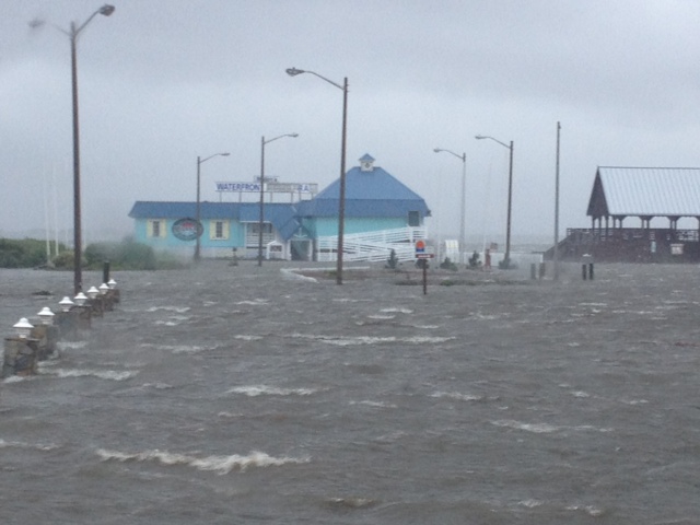
At the height of the storm, about 20 to nearly 30 foot waves were reported off Hatteras Island.
At a news conference Friday morning, Gov. Pat McCrory said there have been no casualties or serious injuries reported.
"That puts a big smile on all our faces," he told reporters.
The governor said the lack of major damage means the beaches will be open for the 4th of July weekend.
"I've put on my beach shirt," he said. "It's time to celebrate Independence Day."
At last report, 9,000 homes and businesses continued to be without power in the coastal counties, with the majority of customers impacted in Carteret County. Ocracoke Island was also without power, and it could be as late as Sunday until electricity is restored fully.
"Details are still coming in about the amount of damage along the coast," Emergency Management Director Mike Sprayberry said. "The state will continue to work with its federal, state and local partners to assess the damage, provide resources and help with recovery efforts."
The Governor said along the coast there there are reports of flooding, minor beach erosion, shingles off homes, and dock damage. He said parts of N.C. 12 from south of the Bonner Bridge to Ocracoke Island along the Outer Banks are impassable due to sand, water and downed power lines on the roadway. That section of the highway is currently closed to traffic. Some areas continue to be impacted by sound-side flooding which will take some time to recede.
"We urge people to stay off the road as much as possible in the impacted areas and allow our crews to complete the work necessary to reopen the road and get residents and visitors back to Hatteras Island as quickly as possible," said Transportation Secretary Tony Tata.
Highway 64 in Nags Head was flooded and roofs were blown off homes and a hotel in Atlantic Beach. Bonner Bridge in Nags Head will not reopen until it has been assessed by North Carolina Department of Transportation officials to make sure it did not sustain any damage.
"It will be a beautiful weekend so get out and enjoy our beaches," McCrory said. "Hurricane Arthur produced heavy rains and strong winds, but we are fortunate to have seen minimal impact to our North Carolina's coastal communities and beaches. We are thankful that our visitors and citizens were kept safe during this storm, and I urge continued caution to beachgoers in regard to the potential for strong rip currents in the days ahead."
Carteret County Manager Russell Overman told ABC11 that several trees and power lines were down in the area causing power outages to almost half the county after Arthur hit the Crystal Coast. It is unclear how long it will take for power to be restored.
"It wasn't that bad, but it was bad enough," he said.
Meanwhile, despite Hurricane Arthur moving off North Carolina shores, the water's strength should not be underestimated.
"Current is strong out there, really strong," surfer Michael Sutton said. "The undertow is really strong, but the current - you can't stay out more than 5 minutes because it will push you sideways."
The National Hurricane Center said Arthur is the earliest hurricane to hit North Carolina in a season since records began in 1851. The previous record was July 11, 1901.


