Gov. Newsom tours North Complex fire destruction in Butte County
Governor Gavin Newsom stressed the need to fast track California's environmental goals as wildfires ravage the state.


BUTTE CO., Calif. -- The North Complex West Zone, one of several wildfires that make up the North Complex, practically exploded in size this week, creating a terrifying situation for Butte County residents.
RELATED: Evacuees describe racing for safety as Bear Fire explodes in size in Butte County
Gov. Gavin Newsom gave perhaps his most impassioned plea for people to recognize and fight climate change as he toured the fire damage on Friday.
He said the state of California is facing the reality of the threat from climate change. "Observe it with your own eyes."
The governor stressed the need to fast track the state's environmental goals. "We're going to have to do more and we're going to have to fast track our efforts... We're going to have to be more aggressive in terms of meeting our goals much sooner."
He made the case that pursing green initiatives is the cheapest way to deal with climate change, the cost of ignoring it is much higher. He says it cost more than $2 billion just to clean up the debris from the nearby Camp Fire in 2018.
Newsom also signed a bill Friday that allows prisoners currently battling the wildfires in the state to get a job in the field when they are released.
The governor declared a statewide emergency over the dozens of fires around California and the extreme weather conditions that made battling the fires even harder.
CALFIRE previously referred to the blaze as the Bear Fire, then announced the name change Thursday morning.
"Tuesday afternoon, the North Complex fire entered Butte County, driven by high winds, heavy fuels and steep terrains," said CALFIRE in an incident update. "Firefighters spent Tuesday into Wednesday morning engaged in lifesaving and evacuation operations."
Crews rescued about 100 residents as the fire wreaked havoc on the Berry Creek and Feather Falls communities.
High winds fanned the flames and pushed the fire southwest straight toward Oroville, and the city is still at risk as of Thursday.
The map from the National Weather Service below shows just how quickly the fire spread overnight into Wednesday morning.
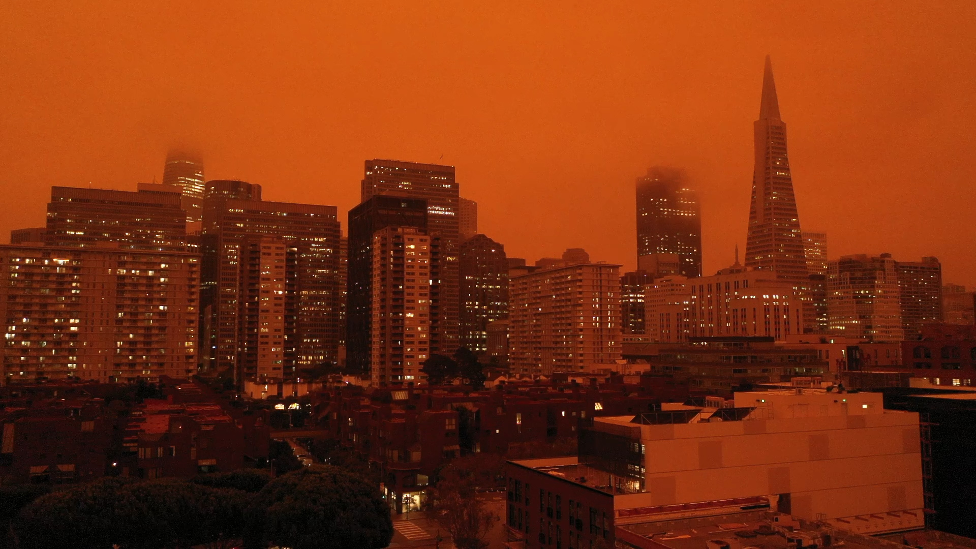
The fire also spewed so much ash into the air, it created an apocalyptic scene 150 miles away in the San Francisco Bay Area.
MORE: Here's why the sky looks so orange, even though Bay Area air quality isn't terrible
The North Complex West Zone turned deadly Wednesday night when three people were found dead, according the the Butte County Sheriff.
Two of those people were found in one location. The other person was in a separate location. No further details about the deaths were immediately available.
Thursday, officials reported discovering seven more bodies, bringing the death toll to 10. Another 16 people are missing.
More bodies could be found as crews manage to make their way into devastated areas. A team of anthropologists from Chico State University were helping in the search, sheriff's Capt. Derek Bell said.
Here's what you need to know about the Bear Fire:
Where is the North Complex West Zone Fire burning?
The fire is burning northeast of Lake Oroville in Butte County, near Plumas National Forest. It's just across Highway 70 from the town of Paradise, which was devastated by the Camp Fire in 2018, and winds were pushing it toward Oroville.
When did the fire start?
The North Complex fires sparked in mid-August amid a lightning storm. The North Complex is burning across Butte, Plumas and Yuba counties.
The West Zone (or Bear Fire as it was previously called) was a relatively small part of the complex until Wednesday morning, when it had erupted in size overnight.
App users: For a better experience, click here to view the full map in a new window
Where are the evacuations?
As of Thursday morning, mandatory evacuations were in place northeast of Lake Oroville, including the communities of Big Bend, Berry Creek, Brush Creek, Junction House, Feather Falls and Merrimac.
Evacuation warnings had been issued for Paradise, Oroville, Bangor and Palermo.
The Butte County Sheriff's Office is tweeting out the latest evacuation orders and warnings here.
How big is the fire?
The West Zone burned 70,412 acres as of Friday morning. It was 5% contained and had destroyed or damaged approximately 2,000 structures.
The North Complex fires altogether were approximately 252,534 acres and 22% contained as of 11 a.m. Thursday.
How are the fires affecting the Bay Area?
Residents in San Francisco and the rest of the Bay Area woke up to eerie orange skies and raining ash Wednesday. That's because a northeasterly wind pushed smoke from the Bear Fire over the region, creating those apocalyptic conditions.

You can see air quality around California using the interactive map below:
App users: For a better experience, click here to view the full map in a new window