Winter weather returns with rain and snow expected in Central CA, Sierra Nevada
It's a drastic change from the spring-like weather we saw over the weekend.


FRESNO, Calif. (KFSN) -- Central California will see winter weather conditions this week, with a chance of showers over the San Joaquin Valley and snow in the Sierra Nevada on Tuesday and Wednesday.
RELATED: Watch ABC30's Accuweather Forecast
It's a drastic change from the spring-like weather we saw over the weekend.
ABC30 Weather Anchor Shayla Girardin says windy conditions were expected Monday afternoon, with gusts ranging from 10 to 15 miles per hour. Higher elevations in the Sierra Nevada could see winds ranging from 25-35 mph with gusts up to 50 mph.
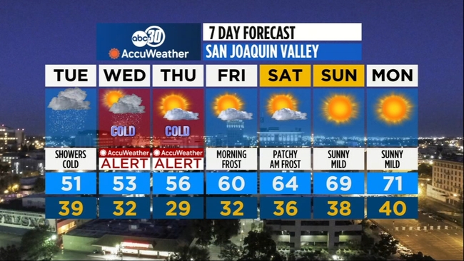
The National Weather Service in Hanford says a storm system will bring a few inches of snow to the Sierra and foothills starting late Monday night. The majority of this storm system will hit Tuesday afternoon and Tuesday evening. Rain will move into the Valley floor starting Tuesday, but it's only expected to be less than a quarter of an inch.
Snow levels are expected to drop to 2,000 feet on Tuesday night, so if you plan to travel over Interstate 5 at the Grapevine or other passes, you should be wary of travel delays.
Overnight temperatures are also expected to drop into the 30s and 40s, and during the day, only up into the mid-50s. A Freeze Watch is in effect for Central California Tuesday through Thursday.
RELATED: TIPS: How do you recover from hydroplaning?

RELATED: Know the Road with the CHP: Preparing for snow and chain control